Walks round the peninsula
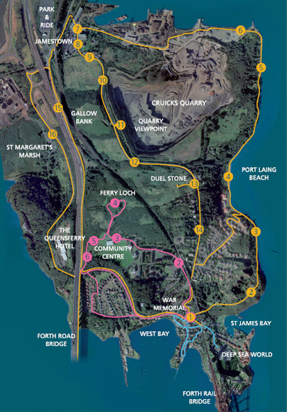 North Queensferry Peninsula is a good area for walking. Follow the suggested route to take in the main sights. The walk will take around two hours to complete. Be prepared for changes in the weather and to wear walking shoes. There are some steeper parts to the route. (The construction of the new Road bridge may lead to temporary or permanent deviations.)
Start at the War Memorial [1] at the foot of The Brae.
(If you are starting from Deep Sea World Car Park, pass under the Forth Bridge, and continue along Old Kirk Road to the War Memorial.)
The route, which follows the Fife Coastal Path, leads through Carlingnose Nature Reserve [2] past The Gov’y Pier [3] along Port Laing Beach [4]before passing through woodland to Industrial Landscapes [5] on Inverkeithing Bay.
Stay on the path when passingCruicks Quarry. [6]
On reaching Jamestown [7] turn left and walk back over Ferry Hills [8].
Ferry Toll Cottage [9] on your left, collected tolls from travellers. Gallow Bank [10] was the site of the Battle of Inverkeithing (1651).
The extent of the quarry can be seen from the Viewpoint [11] about halfway up the hill. Before quarrying began, Ferryhills [12] was the original location of Dunfermline Golf Course. On reaching the outskirts of North Queensferry, a short detour along the track on your right leads to the site of The Last Duel [13] fought in Fife.
From here continue alongFerryhills Road [14], under the Railway Line, and back down The Brae to the War Memorial.
For a longer walk, turn right from Fife Coastal Path at Jamestown, and head towards Inverkeithing. At the T-junction, turn left to Ferrytoll Roundabout. From here, there is a footpath up the access ramp to the Forth Road Bridge [15] (The area around points 15 and 16 will be altered by construction of the new road bridge.) On reaching The Road Bridge, there are steps leading down to the village, to the bridge underpass. The footpath continues across the Forth Road Bridge.
Alternatively, at Ferrytoll Roundabout, pass under the motorway, and follow the B981 towards North Queensferry. The area of Marshland [16] on your right was reclaimed from St Margaret’s Hope, an important anchorage for shipping until Rosyth dockyard was built in the early 20th century. The road continues into the village, along Main Street, back to the War Memorial.
The pink route shown offers a shorter walk.
From the War Memorial [1] climb The Brae. Keeping to the left of the Railway line [2] (do not go under the bridge!) walk along Brock Street past the Railway Station. On reaching the T-junction, keep right and follow the road to the Community Centre [3]. From here you can see to your right the path leading to Ferry Loch [4] the old water supply for the village. Continue along the main path [5] towards the Forth Road Bridge. Look for the bench [6] commemorating those who died while building the bridges, then head down the steps to reach the footpath across the Forth Road Bridge, or continue down the short flight of steps to the Forth Road Bridge underpass.
Steps on the other side, lead to a path to Queensferry Hotel. Cross the road at the foot of the steps, then walk back into the village. Either, follow the route along the main road, or turn right through the stile and follow the path down the long-stride steps. Continue along the path; turn right to reach Ferrybarns Court. Turn left, and left again to pass the Railway Pier, then back along Main Street to the War Memorial.
Have fun exploring!
There are shorter strolls round the village, or longer hikes along the Fife Coastal Path or Pilgrims’ Trail.