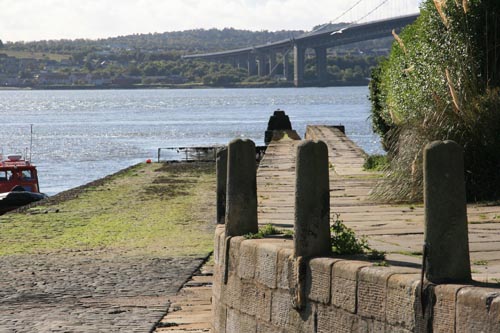
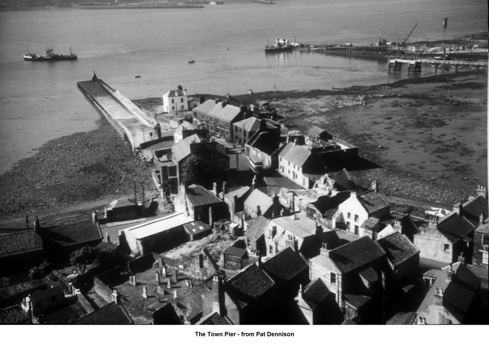
The Town Pier
| < The Ferries | Δ The Queensferry Passage | The Light Tower > |
 Built in 1810-1813 by John Rennie and extended in 1828-1834 by Thomas Telford
North Queensferry has a long history as the northerly point of the Queensferry Passage, known from Pictish times as ‘Caschillis’ or ‘Cilis Cassie’.
The crossing and the two villages, North and South Queensferry, took their names from Queen Margaret, wife of King Malcolm Canmore (1058-93). The Queen provided ships for pilgrims crossing on their journey to St Andrews. There were also small hostelries, or rest houses, at each side of the crossing.
It is uncertain where the first landing places were. The tides and winds would decide where the boats set down the passengers. The travelers were then obliged to struggle over the rocks to dry ground.
As late as the fifteenth century it was decreed that gangplanks should be used for horses and cattle being transported across the Forth but there was no mention that human beings should have this facility!
In the 17th and 18th centuries North Queensferry pier, in its simple form, would have played its part in trading from the Forth to the Hanseatic ports of the Baltic and the Low countries.
Slip landings and primitive piers (remains of which may be seen at low tide) were erected over the years. In 1811 the Ferry Passage was used by 1,515 carriages, 13,154 horses, 18,057 cows, 25,151 sheep, 2,615 dogs and 5,520 barrel bulk – not to mention the people accompanying all of these!
A better pier was essential!
The importance of improving the landing pier at North Queensferry, together with other landing areas in the Forth, was well recognised by the appointment of John Rennie (1761 – 1821), the best-qualified engineer in the country at that time. This historic pier (listed Grade A) was part of an overall construction scheme. The Signal House was built in 1811 to act as a waiting room for passengers on the ground floor, a meeting room and office on the upper floor for the Forth Ferry Trustees. In addition, an octagonal tower was built on the west side that housed the lightroom with the current “state-of-the-art” light. A few years later in 1817, a hexagonal lantern tower was placed at the top of the pier and used the same lightroom technology as the original octagonal tower. At the same time, improvements were made to the East Battery Pier and the West Battery Pier was constructed – both of these can be seen on either side of the Forth Rail Bridge. The roads in North Queensferry were also surveyed by Rennie and the alignment of the main route in the village changed dramatically to cope with the increased traffic.
Improvements meant that, by 1828, 1,000 head of cattle a day could be transported!
Flat-bottomed boats were used so that they could draw up close to the pier.
In 1820/21 a steamboat – The Queen Margaret – came into use and the pier had to be extended to accommodate this new innovation.
Steamboats altered the whole economics of transportation and in 1828 the Trustees consulted the country’s leading civil engineer, Thomas Telford (1757-1834). His recommendation included an extension to the pier into deeper water to make it accessible at all states of the tide. This measure was intended to provide safer wharfage on its eastern side, to protect the extremity of the Battery pier as well as increase the accommodation for larger ships.
He commented that to have extended this pier before the introduction of steamboats would have obstructed the necessary tacks for sailing boats making passage to the south.
All these proposals were subsequently carried out by Telford’s associate, civil engineer, James Jardine (1776-1858).

The Forth Rail Bridge opened in 1890 and, about this time, all ferry traffic transferred to the Railway Pier (built in 1877), leaving the Town Pier to local fishermen.
The Ferry Passage ended in 1964 with the opening of the Forth Road Bridge.
| < The Ferries | Δ The Queensferry Passage | The Light Tower > |