OS Maps and Place Names
The Ordnance Survey – Britain’s mapping agency – has its roots in military strategy: mapping the Scottish Highlands following the Jacobite rebellion in 1745.
It was an innovative young engineer called William Roy who was tasked with the initial military survey of Scotland.
Starting in 1747, it took eight years to complete what was known as the Great Map at a scale of 1:36 000 (1.75 inches to a mile). Roads, hills, rivers, types of land cover and settlements were recorded. William Roy described it as rather a ‘magnificent military sketch than a very accurate map of the country’.
Roy’s surveying parties of about eight relied on simple surveying compasses to measure the angles, and chains up to 50 feet long to measure distance between important features. Much of the rest was sketched in by eye. Nevertheless, the map was a powerful tool as part of a broader strategy to open up access to the Highlands.
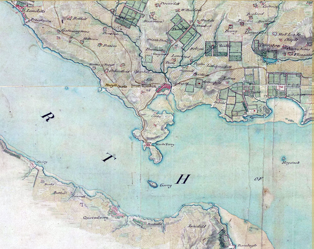
Here is our familiar stretch of the Firth of Forth as depicted by Roy.
On the other side of the English Channel, the French Revolution rumbled on from 1787 to 1799, raising fears that bloodshed might sweep across to our shores.
So the government ordered its defence ministry of the time – the Board of Ordnance – to begin a survey of England’s vulnerable southern coasts, with sufficient detail and accuracy to plan military campaigns and troop movements. The surveyors used theodolites and trigonometry to create an accurate network of triangles based on prominent landmarks. These triangles formed the mapping framework, then the details were added by hand. The early maps featured elaborate hill shading and attention to communication routes, highlighting the emphasis given to military use.
The first Ordnance Survey map (of Kent) took three years to complete; it was published in 1801. Four years later, a map of Essex followed.
The public could buy the new Ordnance Survey maps from the Board of Ordnance headquarters, or from William Faden, a map seller at Charing Cross. They cost three guineas (£3 3s) per county survey, which was between one and three weeks’ wages for the average person. Part of their appeal was they offered a bird’s eye view of the landscape – until then only the privilege of a very few hot air balloonists.
Within 20 years, about a third of England and Wales had been mapped. It was thought that 50 years would be long enough to map the country, but the entire first series of maps wasn’t published until 1870.
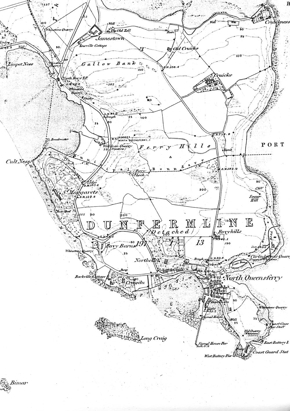
Here is the first OS map of North Queensferry peninsula – dated 1855
Ordnance Survey Name Books
As well as carrying out a survey of the land to create the “artwork” for the map, the map-makers also had to determine the name of each geographical feature that appeared on the map. Place names often proved difficult as locals could argue over what name was actually correct.
Eventually a Name Book system was put in place.
Names were gathered from existing maps and signposts and “prominent local citizens” were consulted. Variations of all proper names such as rivers and hills, as well as towns, were recorded in a series of books and from this selection the most authoritative was chosen for publication.
There are 135 of the books covering the Counties of Fife and Kinross.
North Queensferry
The North Queensferry Peninsula is covered by Volume 76 which includes part of the Parish of Inverkeithing (north of a line from Cult Ness to Port Laing), and a detached part of the Parish of Dunfermline (south of this line.)
The original information is available on the Scotlands People website
Place names in the Parish of Inverkeithing (north of a line from Cult Ness to Port Laing) are:
Cruickness
Cruicks
Firth of Forth
Ferry Hills
Gallow Bank
Inner Bay
Inverkeithing Bay
Jamestown
Limpet Ness
North Ferry T.B. [Toll Bar]
Old Cruicks
Tourville Cottage
The Old Toll
West Ness
Welldean Quarry
Between the entries for West Ness and Witch Knowe, there is a cancelled entry for the Supposed site of Cromwell’s Camp before the Battle of Inverkeithing.
Place names in the detached part of the Parish of Dunfermline (south of the line from Cult Ness to Port Laing) are:
Bimar
Coast Guard Station
Carlinknowes Quarry
Cult Ness
Craigdhu
East Battery Pier
Ferry Loch
Ferry Barns
Ferryhills
Hope Tavern
Inch Garvie
Long Craig
North Queensferry
Northcliff
Port Laing
Post Office
Rockville Cottage
Ruins of a Chapel
Ruins of a Castle (on Inchgarvie)
Remains of a Fort (on Inchgarvie)
School
St Margaret’s
Scaur Hill
Signal House
Signal House Pier
St Margaret’s Hope
West Battery Pier