East Ness, West Ness
| < Cruickness, Cruicks, Inverkeithing Bay | Δ N.Q. Place Name | Supposed site of Camp > |
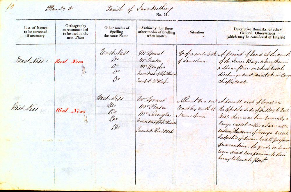
| List of Names to be corrected if necessary |
Orthography, as recommended to be used in the new Plans |
Other modes of Spelling the same name |
Authorities for these other modes of Spelling when known |
Situation | Description Remarks, or other General Observations which may be considered of Interest |
| EAST NESS | East Ness | East Ness | Mr Grant | 5/8 of a mile ENE [East North East] of Jamestown | A point of land at the mouth of the Inner Bay, where there is a stone pier on which vessels discharge and take in cargo chiefly coal. |
| East Ness | Mr Fraser | ||||
| East Ness | Mr Douglas | ||||
| East Ness | Fraser’s Map of Fife & Kinross | ||||
| East Ness | Turnpike Rd [Road] Map | ||||
| WEST NESS | West Ness | West Ness | Mr Grant | About 1/2 a mile East by North of Jamestown | A small neck of land on the opposite side of the Bay to East Ness. There was formerly a large vessel called a Lazarrette where the crews of Foreign Vessels suspected of disease had to perform quarantine. The goods on board were aired here previous to their being taken into port. |
| West Ness | Mr Fraser | ||||
| West Ness | Mr Douglas | ||||
| West Ness | Fraser’s Map of Fife & Kinross | ||||
| West Ness | Turnpike Road Map |
| < Cruickness, Cruicks, Inverkeithing Bay | Δ N.Q. Place Name | Supposed site of Camp > |