Anti-invasion defences – Edinburgh
| < Prestonpans | Δ Index |
A series of six War Department maps dated 1916 (on file WO 78/4396 1916) show the location of a complex of defences protecting Edinburgh from attack from the east. The defences comprised barbed wire entanglements, firing trenches (some of considerable extent and complexity) and defended walls. Some of the firing positions were approached from the rear by complex communication trenches.
The defences ran from the coast at Seafield, to Duddingston and round the south side of Holyrood Park to Craigmillar, to Liberton Tower, and ending just north of Mortonhall. The northernmost section of the defence, at Seafield, had a forward line of defence to its east, at Craigentinny. The defence was split into three sections.
Section 1 covered Seafield to Duddingston.
Section 2 Duddingston Loch to Mayfield Road, beside what is now the King’s Buildings of the University of Edinburgh, and
Section 3 from there to the southern terminal.
Section 1
Section 1 of the defences covered the eastern side of the city from the coast at Seafield to Duddingston. The Section 1 commander was based at Piershill Barracks and was linked by telephone to HQ at Leith Fort, and to seven subsidiary command positions on the defensive line.
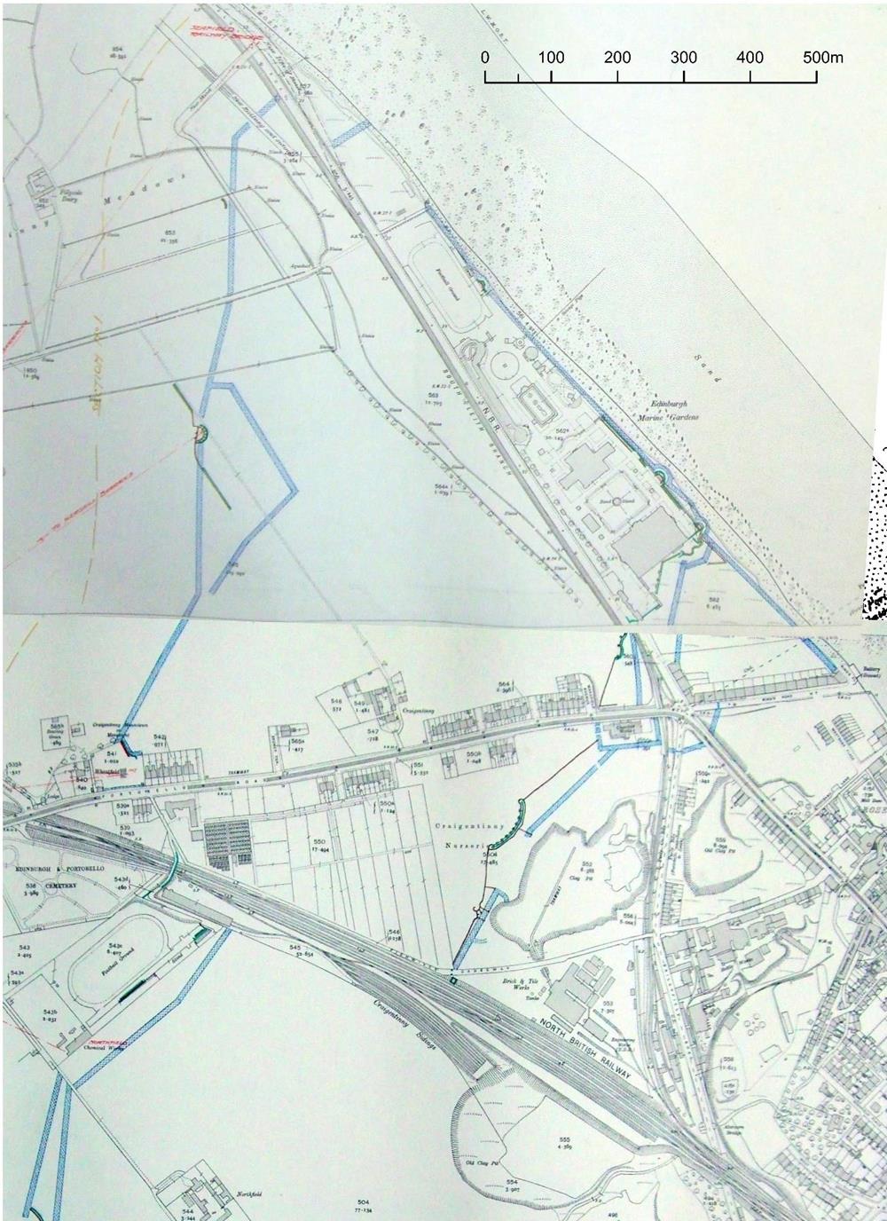 Part of Section 1 of the defences of Edinburgh in 1915, showing the double line of defences and coastal barrier, at Seafield, at the northern end
At the coast, along which an enemy force might be most likely to advance, there were two widely separated lines of barbed wire entanglement, touching the coast to the south-east and north-west of the Edinburgh Marine Gardens at Seafield (an area now occupied by a mass of car sales sheds). The eastern barrier was backed by a near-continuous trench with strong points. The former Chocolate Works (subsequently the W M Ramsay Technical Institute) still standing at the junction, was clearly a strong point. Most of the length of the beach between the two defence lines was also blocked off by a barbed wire entanglement.
Where the wire entanglements crossed the next main road (Willowbrae Road) there was a major strong point formed by interlocking trenches. The wire entanglement ran south-west for about 750m to the eastern edge of Duddingston Village. The south and south-east approaches to the village were obstructed. A final length of wire closed the gap between the village and Duddingston Loch. This formed the south-west end of Section 1of the defences.
A major hutted camp, the base for the 3rd (Reserve) Battalion King’s Own Scottish Borderers from 1916, lay a little to the east of the defences, in Duddingston Park.
Section 2
Section 2 of the defences ran from Duddingston in the north-east to Liberton. The Section Commander was based in the United Free Church at Craigmillar Park and was linked to the Fortress Commander at Leith Fort and to six subsidiary posts on the line.
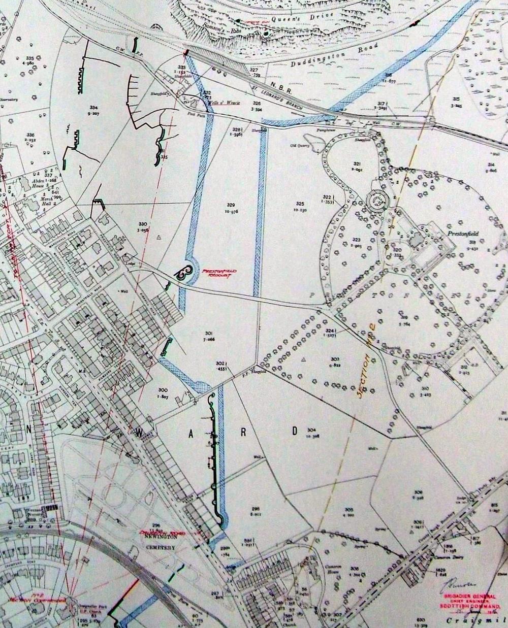 Part of Section 2 of the defences of Edinburgh in 1915, showing the barbed wire barriers, firing and communication trenches running south from Holyrood Park. The Section Commander’s post was in the United Free Church at the bottom left. Two machine-gun positions are marked on Samson’s Ribs
This section of the Edinburgh defences started at the west end of Duddingston Loch and ran, as a double line of barbed wire entanglement, across what is now Prestonfield golf course. Behind (west of) the inner line were complex firing positions with communications trenches and, near the western end of the drive to Prestonfield House, a fortification labelled ‘Prestonfield Redoubt’. Two machine guns were mapped as sited on Samson’s Ribs.
The entanglement continued southwards, behind the tenements of Dalkeith Road, with a continuous firing trench behind it. There were firing trenches in Newington Cemetery and the barbed wire resumed on the south-west side of the railway line, covering the front of the United Free Church in Suffolk Gardens which was the Section Commander’s HQ. The stone wall along the south side of Lady Road was loopholed. Firing positions were placed along Hallhead Road, at that time the southern edge of building. This marked the south-west end of Section 2 of the defences.
Section 3
Section 3 of the defences ran from Liberton at the north-east to the southern end of the defensive line, at Meadowhead Farm. The Section Commander was based at the Royal Observatory at Blackford. The commander was linked by telephone to Leith Fort and to four subsidiary posts; the southernmost was in Liberton Tower.
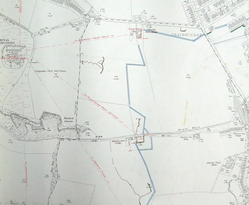 Part of Section 2 of the defences of Edinburgh in 1915, showing the barbed wire barriers, firing and communication trenches. The Section Commander’s post was in the Royal Observatory.
The barbed wire entanglement resumed against the west end of the houses on Hallhead Road, running westward across open fields to Liberton West Mains farmhouse, whose walls were prepared for defence. The entanglement turned southwards from the farm; 130m west of the barbed wire there was a complex firing position accessed by a 110m long zig-zag approach trench.
The barbed wire entanglement continued south with a firing position behind its central point (at NT 2657 6989) and crossed the Braid Burn at Blackford Road Cottage, around which there were firing positions. The barrier continued to Liberton Tower, the courtyard walls of which were used for defence. It turned SSW for about 650m, with two firing positions about 100m behind, to Meadowhead Farm, which was heavily fortified.
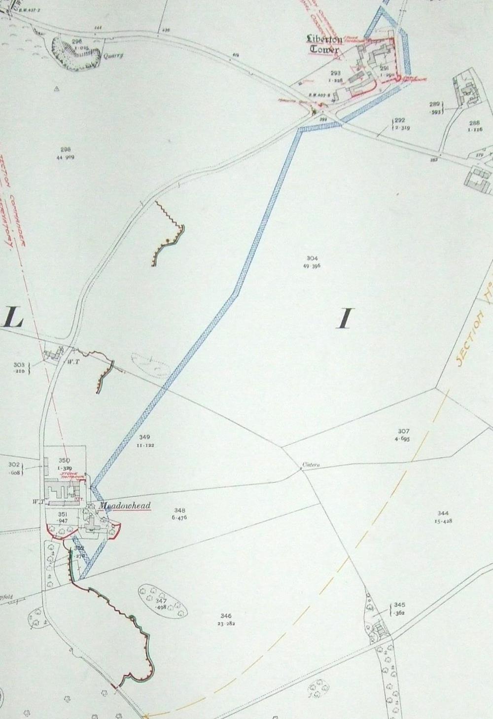 Part of Section 3 of the defences of Edinburgh in 1915, showing the barbed wire barriers, firing and communication trenches. The defences immediately south of Meadowhead are also shown.
It is of this point that we have our single known image of the defences in 1914, a photograph in the collection of Major David Huie of the 9th Battalion, the Royal Scots.
The barbed wire entanglement ended about 60m south of the farm, and the southern end of the defences comprised a single continuous, curved firing trench, about 250m long.
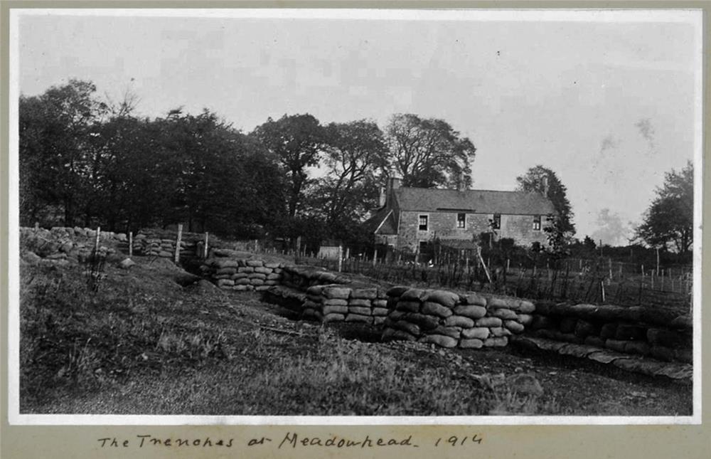 The only known image of the 1914 defences – immediately south of Meadowhead farm, Liberton – a trench fronted by a loop-holed sandbag parapet.
| < Prestonpans | Δ Index |